Teheran Documentation
General Information
Maps
Statistics
Satellite/Aerial Photos
-> Pictures
Publications
WWW Links
Teheran Pictures
Click images to enlarge. See bottom of page for descriptions.
Picture Descriptions
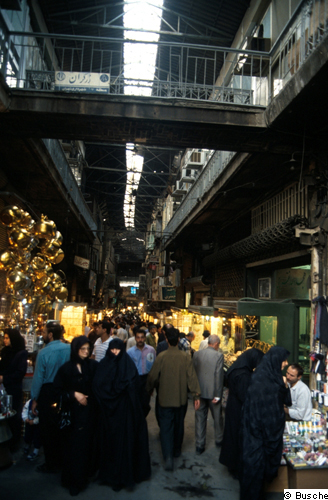
1: A lane in the core of the Great Bazaar (Bazar-e-Bozorg). Situated in the historical center of Tehran, with its area of roughly 200 ha, it is regarded as the largest roofed bazaar of the Middle East. More than 100,000 people work in about 30,000 shops and workshops. Import- and export-oriented wholesale is important, the latter with particular emphasis on carpets. Also in retail the whole range of modern goods are traded. Branch orientation still prevails, as in part of the jewellers' bazaar shown here. Offices occupy the upper one to two floors. Due to its old age it lies several metres below the surrounding city level at its northern front. Because of continuous renewal it is architecturally largely unattractive, with some efforts at repair and improvements in recent years, including bazaar map panels at the gates and street signs, both in Farsi and English. Individual shops are closed with shutters (foreground right). Jewellers' display cases are retracted before closing. As the bazaar has no living functions it is still closed by gates in the evening and during holidays. On holidays only those parts of the bazaar serving the everyday needs of the surrounding lower-class population may be open.
© D. Busche, 1994 [back to picture]
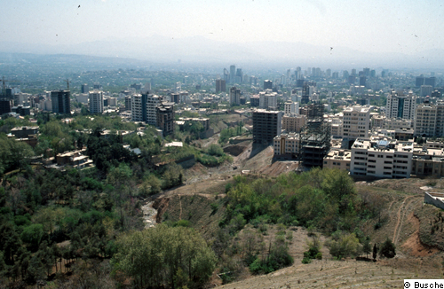
2: View south from the Towchal cable car ground station at the north rim of the city, along the Velenjak Valley (Rudkhaneh-ye-Velenjak). Trees in the foreground have been replanted as a part of considerable efforts at greening the city in the last decades. The upper parts of the alluvial fan system on which Tehran has been built is called Shemiranat (the cooler places; up to 1,700 m a.s.l.). It used to be a village and garden landscape, but largely since the 1950s has become the preferred residential area of the more affluent part of the population, because of lesser heat in summer and less of the smog visible in the background above the low-lying (down to 1,100 m a.s.l.) older and poorer parts of the city. The rapidly multiplying high-rise buildings visible are almost exclusively residential with private ownership of apartments.
© D. Busche, 2000 [back to picture]
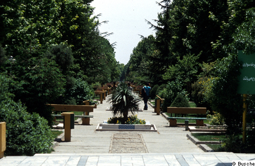
3: Part of People's Park (Park-e-Mellat), lying south of the Tehran International Trade Fair grounds in the north of the city, one of numerous public parks in the city. The part shown here runs parallel to the Vali-ye-Asr Boulevard, one of the older N-S-traffic lines following the slope of the alluvial fans. Well-kept like all Tehran public green, its existence fully depends on continuous irrigation, the water coming from the winter-snow fed streams descending from Mt. Towchal, close to 4,000 m high. Parl-e-Mellat is much frequented during the weekend.
© D. Busche, 1993 [back to picture]
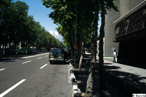
4: Jub-irrigated street trees along one of the N-S-boulevards in the north of Tehran. Corresponding to the Iranians' love of gardens and for improving the city climate, most streets in Tehran are tree-lined, less so towards the densely-built traditional southern parts of the city. As the trees could not survive summer without irrigation, they are planted along, or, as in this case, on the floor of irrigation channels (also used for rain-water drainage) temporarily flooded according to the seasonal needs of the trees. Plane-trees (as here), because of their vast crowns, are the preferred trees for lining the streets, offering shade to pedestrians and parking cars.
© D. Busche, 1993 [back to picture]
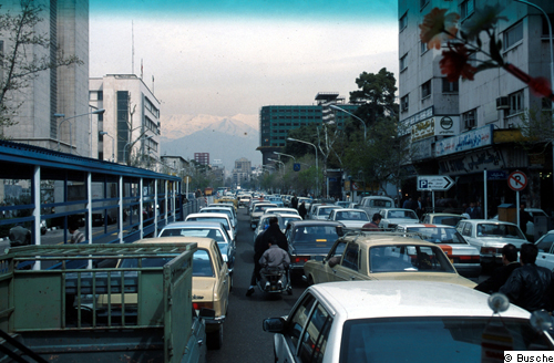
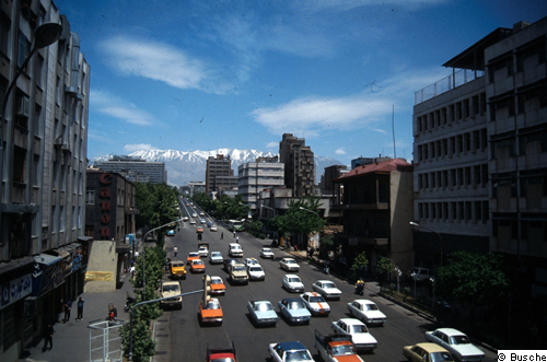
5: Traffic congestion on a N-S street right north of the Great Bazaar, at 12 a.m., with the snow-clad El Towchal plateau of the Elburs Mts. in the background. Fortunately for today's traffic situation, main streets were built four to six lanes wide, together with traffic circles, under the government of Reza Shah in the 1920s and '30s, influenced by German urban planners. Oversized at that time, they are used to full capacity during most daytime hours today. Individual car traffic is enormous, in spite of a large and seemingly well-operating public bus system (roofed bus station to the left). Fastest progress is made by scooters and small motor bikes, which can also be hired like cabs around the bazaar. Cabs are orange or marked by stripes (also orange in this case).
© D. Busche, 1999 [back to picture]
6: View east along Azadi Boulevard from the traffic circle of the Azadi Monument ( hier Hinweis auf das entsprechende Bild) (Meydan-e-Azadi), the main axis to the economic city center of the 1970s. This was the western rim of the city in the 1970s when Mehrabad Airport was still out of town. Since the Islamic Revolution and the war with Iraq in the 1980s practically all fire walls have been painted with political propaganda. In recent years there has been a trend, though, to presenting idyllic humid-climate landscapes, as in the foreground right.
© D. Busche, 2000 [back to picture]
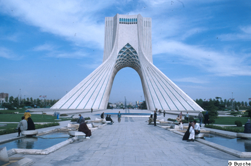
7: Tower of Freedom (Borj-e-Azadi), opened in 1971 as Shahyad-Ariya-Mehr Monument on the occasion of the 2,500 year celebrations of the Iranian kingdom and renamed after the Islamic revolution of 1979. The 50 m high tower, clad with over 25,000 limestone slabs, merges architectural elements of pre-Islamic Sasanide and Islamic architecture. When built close to Mehrabad Airport the gate marked the western rim of Tehran. Since then the city has grown far beyond it to the West along the axis of the Karadj Freeway.
© D. Busche, 2000 [back to picture]
8: Part of the limited-access freeway system of Tehran in the north of the city. Surrounding the inner city of the early half of the 20th century there is a still-expanding, roughly rectangular grid of multi-lane freeways growing since the 1960s, best developed in the northern part of the city. The N-S segments of the system were less problematic to construct, as they largely follow the stream valleys extending south from the Elburs mountain rim. The E-W sections have to cross the deeply incised, box-shaped streambeds dissection the Quaternary alluvial fan landscape in bridges.
© D. Busche, 1993 [back to picture]
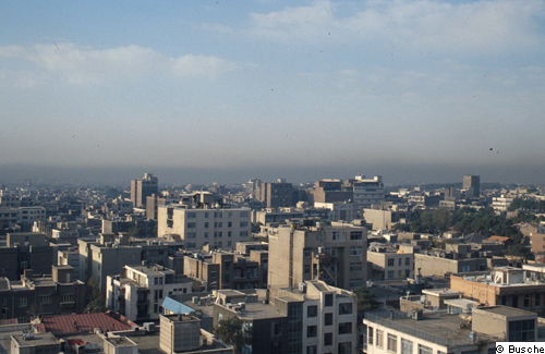
9: Looking south from northern Tehran. The city is spread out on intersecting and dissected alluvial fans descending from about 1700 m to below 1000 m close to the Kavir of Ghom (or Qum). In order to cope with the scarcity of space in the metropolis, there are often only narrow alleys branching off the N-S arteries in the residential quarters of midtown Tehran. Increasingly older buildings only one or a few stories high are either raised by several more stories, statics permitting, or are replaced by higher buildings. Predominant high air pressure above the city, together with heavy car traffic still using unleaded fuel causes severe smog throughout most of the year, at its worst in the lower lying central and southern parts of the city, as shown here.
© D. Busche, 1994 [back to picture]
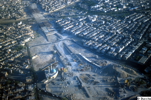
10: Part of the second Otoban-e-Tehran-Saveh southwest of Mehrabad Airport under construction. The first limited-access turnpike running westward from Tehran along the Elburs front , the Karadj Freeway, was built in the 1970s, following the American style of turnpikes. Since the revolution in 1979, in addition to enlarging the capacity of the toll-free roads (bozorgrah) radiating from Tehran, ten toll roads have been completed or are under construction, from that to Garmsar leaving the city to the southeast, to the currently longest one leading southward to Esfahan (close to completion), and the one shown here, plus a section of the inner-urban limited-access road system, the Otoban-e-Evin on the north rim of Tehran. The name adopted for the toll-roads is the phonetically modified German term "Autobahn". All traffic information is in Farsi and English or transcription into Latin letters.
© D. Busche, 2001 [back to picture]
11: N-S one-way street with fly-over and Mt. Towchal in the background, in midtown Tehran. To reduce traffic congestion along already existing main thoroughfares within the city, steel-construction fly-overs have been built across intersections. The flyover in the rear was photographed from another one crossing the street shown. Lanes are often not marked, as in the foreground, but are not likely to be observed even if they were there. The cars with orange hoods or stripes are cabs.
© D. Busche, 1993 [back to picture]
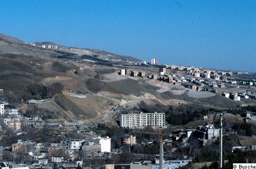
12: City enroachment on the slopes of Mt. Towchal, close to 2,000 m a.s.l., east of the valley and former village of Darabad. Because of lower summer temperatures and less air pollution there has been a northward spread of the city for decades towards the mountain front , around 1,700 m a.s.l. This view, from the rather new Nature and Wildlife Museum on an outlier hill, is towards the highest-reaching and, of course, high-income housing area. Building permits are reported to be often dubious. Water supply, due to high pumping costs, is problematic. Apartments are privately owned. Afforestation projects are frequent along the mountain front.
© D. Busche, 1999 [back to picture]
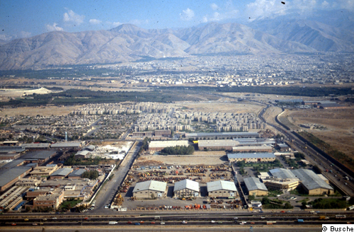
13: City growth westward towards Karadj. The fringe of alluvial fans along the Elburs Mts. from Tehran to Karadj and beyond, the Otoban-e-Tehran-Kardaj toll road being the backbone of this development. Large public and private housing complexes, mostly high-rise, have come into existence, interspersed with relics of the traditional garden and irrigated farmland landscape and new afforestation. There is also a continuous strip of manufacturing plants on spacious lots, as in the foreground. Almost the only remaining open spaces in the plain (dasht) are the braided channel floodplains of the intermittent rivers emerging from the mountain front, with frequent gravel extraction there.
© D. Busche, 1994 [back to picture]
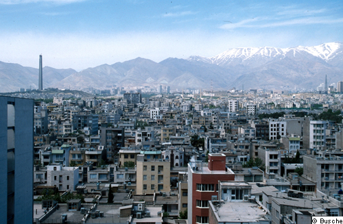
14: View north across the densely-built city towards the Towchal mountain front, from the top floor of the Laleh Hotel in midtown Tehran. The replacement of older low buildings by taller apartment houses and high-rises, to overcome the scarcity of land within the city, as well as the spread up the mountain front are clearly visible. The telecommunications tower, still without its antenna when the picture was taken, upon completion will be the tallest building of southeastern and southern Asia.
© D. Busche, 2000 [back to picture]